
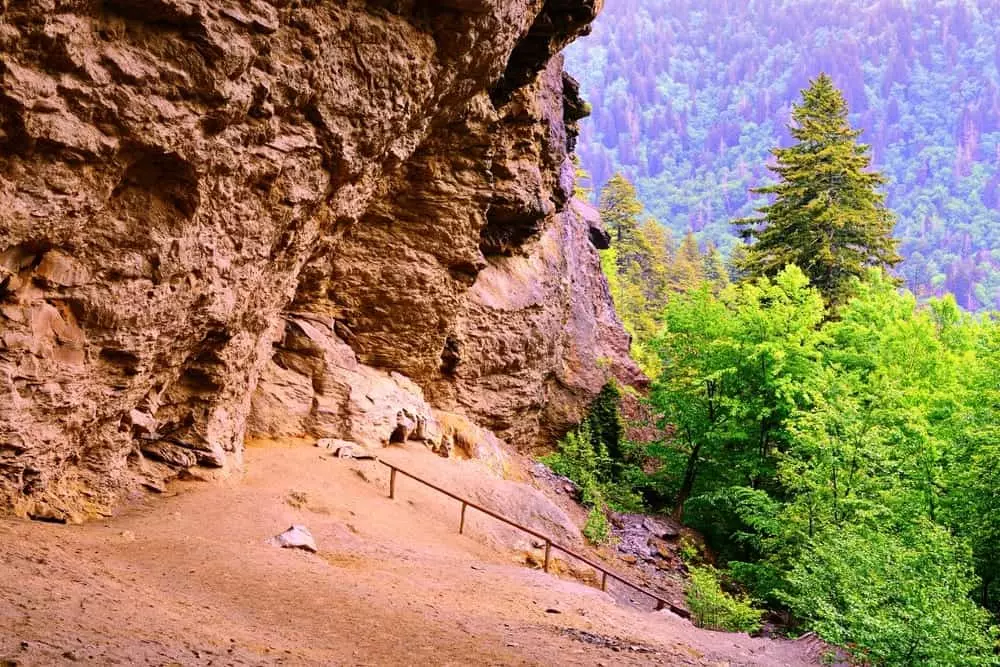
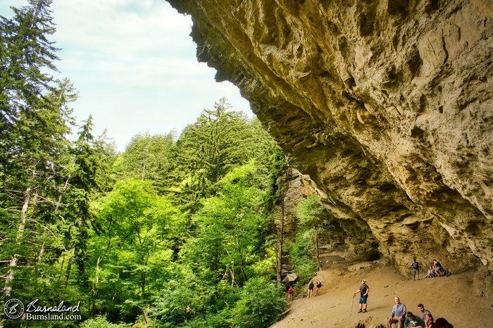
When most people hear the name Alum Cave, they picture a cavern. In reality, it’s not a cave at all but a massive concave bluff carved into the side of Mount LeConte. Towering about 80 feet high and stretching more than 500 feet across, this natural amphitheater was formed over millions of years as water, wind, and shifting rock slowly eroded the softer layers of the Anakeesta Formation. Today, it’s one of the most dramatic natural features along the Alum Cave Trail, drawing thousands of hikers each year who want to rest beneath its sheer rock overhang and soak in panoramic views of the Smokies. To see a full trail overview, click here.
A Mining Hub in the 1800s
The bluffs weren’t always just a hiker’s destination. In the mid-1800s, Alum Cave was at the heart of a bustling mining operation. Locals discovered deposits of alum, Epsom salts, and saltpeter in the rock, each with valuable uses. Alum was prized for tanning leather and dyeing cloth, while Epsom salts were sold as a medicinal remedy. Most importantly, saltpeter became a critical ingredient in the production of gunpowder. During the Civil War, the Confederate Army relied heavily on minerals extracted from Alum Cave, turning this scenic bluff into an industrial supply point. You can read more about its Civil War role here.
Hiking to the Bluffs
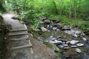
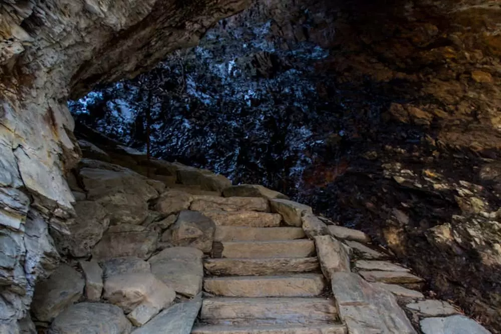
Today, the mining is long gone, but the trail to Alum Cave remains one of the most traveled paths in the Smokies. The hike to the bluffs is about 2.3 miles from the trailhead and is considered moderately strenuous, with an elevation gain of roughly 1,200 feet. Along the way, hikers pass through old-growth forest, cross log bridges over rushing streams, and navigate landmarks like Arch Rock, where stone steps carry you through a naturally formed archway carved from solid rock. Many hikers stop at the bluff itself, which offers sweeping views and a natural shelter from sun or rain. For a breakdown of key trail highlights, click here.
Alum Cave and Mount LeConte
For those looking for more than a half-day hike, Alum Cave is just the halfway point. Beyond the bluffs, the trail climbs steadily toward the summit of Mount LeConte, the third-highest peak in the Great Smoky Mountains National Park. Continuing the trek adds another 3 miles, bringing the total to 5.5 miles each way, but the reward is unmatched: breathtaking views from the summit and the chance to stay overnight at the rustic but legendary LeConte Lodge. Hikers who make it up often describe the journey as one of the most iconic experiences in the park. To plan a full hike up LeConte via Alum Cave, click here.
Why the Bluffs Matter
What makes Alum Cave so special is the way it combines geology, history, and modern adventure. The rock walls tell the story of ancient natural forces, while the remnants of mining recall a chapter of human industry that helped shape the region’s past. Today, standing beneath the massive overhang, hikers can look out across the Smoky Mountains and reflect on both the beauty and the legacy of this place. For another perspective on why Alum Cave is considered an “iconic trail,” click here.

Directions
The Alum Cave Trailhead lies along Newfound Gap Road (US‑441) between Sugarlands Visitor Center near Gatlinburg and Newfound Gap.
From Gatlinburg, drive 8.6–8.7 miles south on US‑441. Look for a marked trailhead on the left. There are two parking lots, one directly after the other, where the trail begins between them. The lower end of those lots has public restrooms.
- From Cherokee (North Carolina), head north on Newfound Gap Road. The lots will appear about 23 miles from the NC entrance, around 5 miles beyond Newfound Gap overlook, on the right side.
Parking Tag Requirement
Great Smoky Mountains National Park requires a parking tag—daily ($5), weekly ($15), or annual ($40)—for any overnight or daytime parking beyond 15 minutes. This tag is not an entrance pass, and must display your license plate. Acceptable tag forms include physical printed tags placed on the dashboard (digital versions are not allowed).
Tags are available online (Recreation.gov) or in person at locations like Sugarlands Visitor Center, Gatlinburg Welcome Center, or at kiosks at various park locations. Plan ahead: in‑person tags expire at midnight.
Note that tags do not guarantee parking. Trailhead lots fill up early—on busy weekends they can be full by 8–9 AM.
Parking Capacity & Tips
There are two main lots, but overall space is limited and fills fast. Overflow parking along the road is not officially allowed but commonly used when lots are full. One hiker recommended arriving at dawn, especially on weekends, to secure a spot or risk being forced to walk from farther down the road.
Once parked, the trailhead has a pit toilet. Beyond that, restrooms are absent until reaching Mount LeConte Lodge.
Distance and Difficulty
The trail stretches 5.5 miles one way (11 miles round trip) to the summit of Mount LeConte. The first 2.3 miles take you to the Alum Cave Bluffs, a popular turnaround point for those not continuing to the summit. According to the guide, the hike is rated moderate to strenuous, with an elevation gain of roughly 2,700 feet, making it manageable for fit beginners but still challenging enough for seasoned hikers. For a detailed breakdown of elevation and distance, click here.

Trail Features
Hiking in the Smokys highlights some of the key landmarks along the way. You’ll pass Arch Rock, a natural rock arch that hikers climb through using a staircase of stone steps; Inspiration Point, which offers sweeping vistas of the valley; and the Eye of the Needle, a hole in the rock near Peregrine Peak where rare birds of prey are sometimes spotted. Each of these features is carefully explained on their site, so if you want a landmark-by-landmark breakdown, click here.

Best Seasons to Hike
The website also notes that Alum Cave is spectacular in every season, but each brings its own character. Spring and summer fill the trail with wildflowers and greenery. Fall transforms the mountainside into a tapestry of fall colors, while winter can create a wonderland of ice formations on the bluffs. Because of steep climbs and icy sections, winter hikers are advised to bring traction devices like microspikes. To see what conditions are like season by season, click here.
The Alum Cave Trail is more than a walk in the park—it’s a journey through geological wonder, history, and high-altitude beauty. Here are the top things to do while hiking the trail, packed with detail and context to bring each moment alive.
1. Marvel at Arch Rock
Roughly 1.4 miles into the trail, hikers cross a log footbridge over Alum Cave Creek and arrive at Arch Rock, a natural stone arch carved by centuries of freeze-thaw erosion. A narrow path leads through the arch via stone steps and a cable railing—making it both dramatic and accessible. It’s a perfect early spot for a photo or pause
2. Breathe Deep from Inspiration Point
About 2 miles in, Inspiration Point offers sweeping views from a heath bald. On clear days, you’ll see ridges like Chimney Tops, Sugarland Mountain, and Anakeesta Ridge, as well as the distinctive “Eye of the Needle”—a hole in a ridge that catches the light just right. It’s a great spot to rest, reflect, and take in the Smoky Mountain layers.

3. Spot the Eye of the Needle
Adjacent to Inspiration Point, you might notice the Eye of the Needle—a naturally formed window through rock on Little Duck Hawk Ridge. It makes for a unique photo opportunity and highlights the dynamic terrain above.
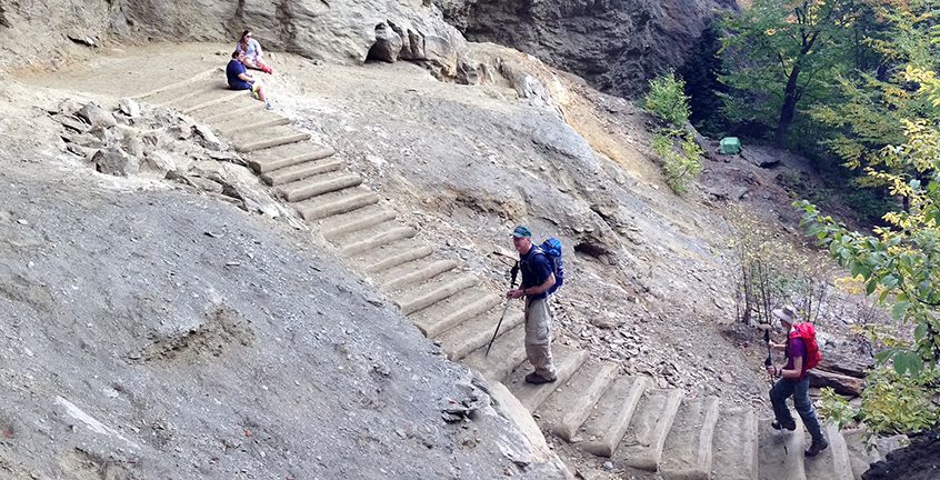
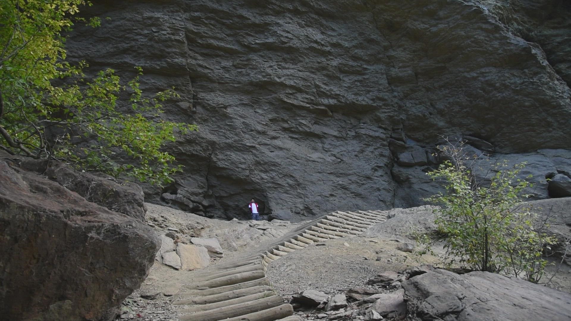
4. Navigate the Iconic Log Steps
Shortly before reaching the bluffs, hikers climb impressive log steps built into the mountainside. These rustic steps—compact logs layered into the trail—offer both charm and support on the steepest ascent.
5. Stand Beneath the Alum Cave Bluffs
At about 2.2 miles from the trailhead, you arrive at the famous Alum Cave Bluffs—a massive sandstone overhang rising nearly 80 feet. The bluff provides natural shelter and panoramic views, making it a favorite turnaround spot. Listen for the faint mineral scent in the air and watch for icicles hanging in winter.
6. Continue to Mount LeConte (for the adventurous)
This midpoint is only the beginning. If you’re up for a challenge, continue on toward Mount LeConte, reaching the summit via another 3 miles and ascending over 2,700 feet in elevation. From the top, explore overlooks like Cliff Tops and Myrtle Point, or stay overnight at LeConte Lodge, the rustic inn tucked into the spruce-fir forest.
| Thing to Do | Description |
|---|---|
| Arch Rock | Walk through a dramatic natural stone arch with built-in stairs |
| Inspiration Point | A scenic overlook offering ridge views and fresh mountain air |
| Eye of the Needle | A mountain “window”—a distinct rocky hole—visible from the overlook |
| Log Steps | Rustic log steps built into the trail leading to the bluffs |
| Alum Cave Bluffs | Massive overhang offering shelter, views, and historical vibration |
| Summit LeConte | Extend to the summit for overnighting at LeConte Lodge and summit views |